Ground investigation for a proposed substation Loch Buidhe
Igne was commissioned by SSEN Transmission to undertake the ground investigation at this proposed substation site at Loch Buidhe. The investigations were needed to provide information on the ground conditions for foundation design and construction of the proposed works and in relation to any geochemical contamination of the site.
Pathway to 2030 programme
Scottish and Southern Electricity Networks (SSEN) Transmission is investing £20bn in its Pathway to 2030 programme to help unlock cleaner, more secure energy for homes and businesses for generations to come.
The investment programme consists of new overhead lines, substations, convertor stations and subsea links and is part of a major upgrade of the electricity transmission system across Great Britain.
These works are required to meet UK and Scottish government energy security and climate change targets, with the need for these investments independently assessed by the Electricity System Operator, and approved by the independent energy regulator, Ofgem.
As part of the Pathway to 2030 programme, SSEN Transmission is reinforcing the overhead line network from Spittal to Loch Buidhe to Beauly. To connect the new 400kV overhead line, a new 400kV substation is required near the existing 275kV substation at Loch Buidhe.
Igne was commissioned by SSEN Transmission to undertake the ground investigation at this proposed substation site at Loch Buidhe. The investigations were needed to provide information on the ground conditions for foundation design and construction of the proposed works and in relation to any geochemical contamination of the site.
On site environmental and ecological challenges
The site is situated approximately 7km to the northeast of the village of Bonar Bridge in Sutherland within an area of commercial forestry. Consent for works was granted by NatureScot as the site is within the Strath Carnaig and Strathfleet Moors Special Protection Area and Site of Special Scientific Interest.
Protected species include hen harriers, red squirrels, and pine martins, so an Ecological Clerk of Works was employed to be on site to minimise any potential environmental impact and to ensure no harm to any protected species occurred during the works.
There are no designated archaeological or cultural heritage assets on the site, however there was a possibility that non-designated assets or artefacts may be present, therefore a specialist archaeological presence was also required during the site works.
An archaeologist, employed by SSEN Transmission, provided a watching brief over excavations including inspection pits, trial pits and in-situ soakaway testing pits.
Igne’s programme of ground investigation consisted of:
- 19 dynamic sampling boreholes with 12 rotary core follow on
- 21 trial pits
- 4 in-situ soakaway tests (to determine permeability and drainage of the underlying till)
- 11 thermal resistivity tests (where cabling is anticipated)
During the site works a further 204 peat probes were added to determine the depth of peat.
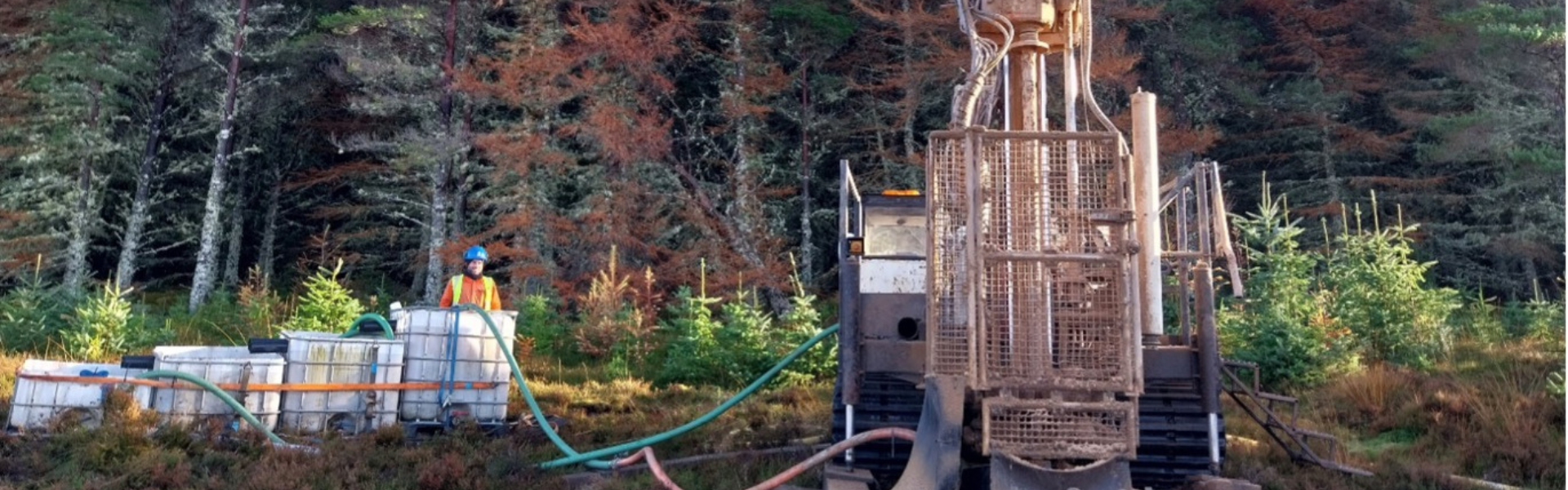
Igne utilised the following plant:
- Fraste PLG (which is the newest rig in the fleet) dual dynamic sampling and rotary rig with compressor and water support unit
- Commachio 205 dual dynamic sampling and rotary rig with compressor and water support unit
- Two BV 206 Hagglund support units
- Two MAN water trucks
- Two geothermal water loop winders (to supply 32mm polyethylene water pipes to rigs)
- 14 tonne Doosan Low Ground Pressure Excavator (for trial pits)
- 13 tonne Doosan Excavator with Grab (to move brash from other areas of the site to assist creation of access roads where ground is soft. In addition, repair existing brash tracks)
- Morooka 1500 (to assist moving brash from other areas of the site)
All cores were taken utilising a water flush medium. Clean water was taken from the nearby Loch Buidhe and transported by water truck to the site where it was then pumped to the rigs through 32mm alkathene pipe via geothermal loop winders. At the rigside, the water was then recirculated through a closed system.
What the site investigation revealed
The site comprised peat overlying a morainic glacial till, in turn overlying bedrock consisting of psammite and granite. Peat probes were carried out at 50m centres within the proposed site with some further probes strategically located to the west and east out with the proposed site. The depths of peat ranged from 0.30m to 4.90m.
The Morainic glacial till deposits consisted of granular sand and gravel with cobbles and boulders. The bedrock consisted of metamorphic siliceous to feldspathic (occasionally micaceous) psammite of the Altnahara formation and latter granitic intrusions associated with the Migdale pluton. Bedrock was encountered between 2.00m to 8.00m approximately across the site.
On site monitoring of gas and water levels was carried out during the site works. This included the development of wells after the installation of standpipes. A longer-term monitoring regime will consist of gas and water level readings once a month for a period of six months. Water samples may also be requested.
Soil samples and rock core were logged and photographed on site prior to being shipped to Igne’s laboratory for testing and storage. Geotechnical and rock testing was scheduled by the Investigation Supervisor to be approved by the client and carried out at the Igne lab in Airdrie.
The duration of on-site works took 6 weeks; this was followed by the draft factual report within 4 weeks of the site completion.
Contact Igne's site investigation experts to discover more about the ground beneath your feet.